From OTV
GPS tracking
GPS tracking is an important part of all orienteering TV productions except for sprint in urban areas where the GPS coverage is usually not good enough with today's technology. This section covers all aspects related to GPS tracking in TV productions.
A section discussion "Best practise" for use of GPS tracking in TV productions has been set up. This section will evolve during the project based on input from different sources. The best practise section is thought to be the basis for a future production manual for orienteering TV productions.
The best practise section is based on a lot of background information which details different concepts, scene types etc.:
- GPS visualization graphics. 3D / 2D / orienteering map / simplified map / satellite picture / hill shading map ...
- GPS tracking modes. Real time / From start / From control / Sync ...
- GPS tracking providers. GPSSeuranta / TracTrac ...
GPS tracking best practise and improvements to current state-of-the-art
This set of best practise for GPS tracking are a results of work in the current project and discussions at the SOFT TV Workshop in February 2012.
- GPS-tracking: Do not ever use the 3-letter description for names of runners - always use full names (or at least last names).
- GPS “mode symbols”: The symbols for “LIVE”, “SYNC” etc. must be bigger and better visible
- Graphics should be integrated in GPS-tracking to use the graphics profile of the broadcast also for the GPS (comment: GPSSeuranta has the possibility to let TV handle graphics via XML-eport).
- A descriptive text about what is shown should be included each time GPS-tracking is shown (for example: “Gueorgiou versus Nordberg on 4th-5th control”). Graphics profile of the broadcast should be used for this.
- Country flags accompanying the “dot” for each runner should be used in relays (and the possibility also explored for individual start races)
- GPS visualization: Hill-shading map is a very good way to show longer routechoice legs - should be used for long legs whenever possible. For shorter legs / close-ups, we for now have no better alternative than the normal orienteering map, but one should try to harmonize colors etc. to let the viewer recognize the map from event to event (Bernhagen: “The orienteering map is maybe too difficult - it should look the same from time to time”). Also, try out hillshading map to see how it works for shorter legs.
- GPS is often shown too fast/short in today’s TV broadcast - the viewer and commentator must understand what is happening. If the GPS shown is relevant, it should be at least 10 seconds long. One alternative which should be explored is to first visualize which leg is the focus, and then show the GPS-tracking (i.e. it takes 2 seconds before the GPS-tracking starts)
- GPS “Time to Beat” sequence: The suggested “Time to beat” sequence where one leg is shown again and again for each runner coming up to try to set a new best time, should be explored further - especially for long distance races where there are often too few cameras.
- Choice of legs: “Who is the winner” must be focus each time GPS-tracking is shown - use GPS-tracking as part of the storytelling for who wins the race. Show GPS-tracking for the parts of the course which have special challenges.
- The tail length in the GPS-tracking should probably be standarized for cases where there is no special reason to have a specific length ( = easier for commentator and for viewer). Typical length could be 1 minute.
- Best/expected route chocies: It should be aimed at finding a good way to show “expected routechoices” in the GPS-tracking to let “the viewer understand more than the runner”.
- Forking: When forking is used in e.g. relays, it should be shown in the GPS-tracking which control which runner on the map (for a relay there could be flags beside each control ; for an individual race there could be runner names, alternatively using the graphics in a different way).
- It was agreed that sync of GPS and camera was a good way to show the runners, but there is too much delay and it is therefore challenging. It should be explored further using e.g. EVS to delay cam.
- Athlete profiles should be shown in graphics both during GPS tracking and at other times.
- The commentators need the maps at least 1 hour before the race to prepare for the broadcast. The map should ideally be accompanied with details about excpected route choices etc. from the course planner.
Other thoughts related to GPS tracking best practise:
- When top athletes are behind at a TV-control, or have lost time between TV-controls, this should be shown directly after the athlete has passed (if not already shown live/instant replay as it happened)
- When athletes are making mistakes or taking different routes- they should be compared to current leader.
- Never show more than 2-3 athletes at GPS-tracking if there is no very special reason for it
- GPS tracking is often shown too fast - slow down to make it possible for non-orienteering viewers to understand what happens. When a single leg is shown, it can be an idea to first show the leg itself for some seconds with a graphic indicating which leg is to be shown, and then start the tracking when the viewer/commentator is "ready".
- Need clear strategy about which types of scenes to be shown using GPS-tracking.
- Tip: Why not use GPS Live Sync from start for the last starter (or main favourite) along with current leader to the first control? Could be good way to "follow" last starter/top favourite into the course and get a feeling for the race development? Get the "Live" feeling into it.
Important notes about GPS Tracking
For all TV-broadcast events the potential GPS coverage fallout-problem due to overuse of GPRS/GSM-network must be given high priority. This is a major issue as the TV broadcast is very dependent on stable GPS data via the GPRS network.
Solutions is a combination of:
- Cooperating with the Telecom-companies who must increase the bandwidth for data in the event area (main priotity - this is an absolute must, and can be costly)
- Use a mix of SIM-cards from different providers (if there is coverage in the competition area for more than one provider - this is done regularly in Finland)
- Offer local WLAN for results in the arena (to reduce GPRS-use)
- Ask spectators to not use data on their mobile phones
Position tracking in urban sprints
GPS tracking is currently not applicable in urban sprints due to inaccuracies in GPS data due to buildings etc. In the SOFT TV Workshop, it was put focus on the fact that new technology is needed for position tracking in urban sprints.
One promising technolgoy:
- Indoor positioning system http://www.navigadget.com/index.php/2012/04/25/ips-next-generation-of-gps-for-smartphones/
GPS visualization graphics
Below different GPS visualization graphics are exemplified. Nota that there is also an interesting article on the topic which can be found here http://icaci.org/documents/ICC_proceedings/ICC2011/Oral%20Presentations%20PDF/A3-Thematic%20maps,%20orienteering%20map/CO-010.pdf
- 2D - Normal orienteering map visualization. The normal way to visualize. Used in most productions.
- 2D - Show country flag for each runner
- 2D - Simplified orienteering map visualization. Orienteering map where some details are removed to make the map easier to understand. Some trials have been made.
- 2D - Orienteering map with hill shadingvisualization. Map has been made for WOC 2010 area, but not used for GPS tracking until now (as far as the authors know). However, looks visually pleasing and promising for future GPS tracking.
- 2D - Satellite picture visualization. Used for big screen production and 10Mila production in some cases.
- 2D - White background visualization. A "necessary evil" for relays where there is no quaranteen. Should be avoided if possible.
- 2D - SYNC GPS and camera footage
- 3D Google Earth (3DRerun) visualization. Only used for "instant replay" and "course replay" for now. Has been used at WOC 2010 and in big screen project of Norwegian Orienteering Federation. Can be either orienteering map or satellite picture.
2D - Normal orienteering map visualization
The normal way to visualize. Used in most productions. Sample is from GPSSeuranta.
2D - Show country flag for each runner
The GPS tracking provider TracTrac used GPS graphics with a small country flag superimposed for each runner at WOC 2008 Long and WOC 2008 Middle.
2D - Simplified orienteering map visualization
An orienteering map where some details are removed to make the map easier to understand. There are no big disadvantages with this approach, except it may get irritating for the experienced viewer who does not get all the information which the runner has available.
2D - Orienteering map + hill shading visualization
A map has been made for the WOC 2010 area and was used for the long legs on WOC 2010 long. Looks visually pleasing and promising for future GPS tracking. It is quite straightforward to make this type of hill shading map in OCAD if you have a digital elevation model available (often the case for high level events). One should probably simplify the map in addition to adding hill shading as the map may get a bit too complex (this is done for the WOC 2010 case).
Example from WOC 2010 Long broadcast:

2D - Satellite picture visualization
Used for big screen production and 10Mila production in some cases. This is an alternative to the blank (white) map for cases where there is not sufficient quaranteen.
2D - White background visualization
A "necessary evil" for relays where there is no quaranteen. Should be avoided if possible. This sample is from Jukola (screenshot from YLE) - similar arrangement also used for e.g. WOC relay 2011.
2D - SYNC GPS and camera footage
Very innovative solution used in WOC 2008 Middle which shows the GPS tracking in sync with the camera footage.
3D Google Earth (3DRerun) visualization
Only used for "instant replay" and "course replay" for now. Has been used at WOC 2010 and in big screen project of Norwegian Orienteering Federation. Can be either orienteering map or satellite picture.
GPS tracking modes
There are several different ways to show GPS tracking data. In the following it is attempted to break it down into different categories.
GPS data can be played either live or replay:
- LIVE (always 1x speed)
- REPLAY (either 1x speed or higher speed)
GPS data can be played either with the same start-time/zero-time for all athletes, or with offset of runners to make it possible to play different types of simulated mass starts. Three different modes are defined:
- Mostly individual start races: GPS SYNC modes. Runners are synchronized to start at the same time (simulated mass start). Aim: Show who is in the lead / relative position of the runners at any position in the course. Nearly always used in individual start races. Not relevant in mass start races. Seldom used in chasing start races.
- Mostly first-to-finish races: GPS REAL TIME modes. Runners are shown real time without offset relative to each other. Aim: Show how the runners are positioned relatively to each other in the course, and how they influence each other. Nearly always used in First-to-finish races. Seldom used in individual start races.
- All races: GPS LEG REPLAY modes. Runners are synchronized to start at the same time from a control, i.e. simulated mass start from control. Either used live or replay. Aim: Show the influence of a given leg on the race development. Compare different runners for a given leg. Sometimes used in any type of race in order to better visualize a decisive stage in the course. Challenging to explain for the viewer. Never used live.
Notes:
- For each of the categories, any number of runners can be shown simultanously for the GPS tracking.
- A special symbol should be used to indicate which mode is used (this is implemented for GPSSeuranta)
In addition to these modes, there are also some special mode which should be explained separately:
- GPS Show mistake/time loss scene
- Show time difference between two runners
- Transition from GPS to camera footage
GPS SYNC modes
Runners are shown synchronized to same start time from the start of the course, i.e. simulated mass start from the start of the course. This mode is only relevant for interval start events.
- GPS REPLAY SYNC
- GPS LIVE SYNC
- GPS REPLAY SYNC TO LIVE SYNC transition
- GPS TIME TO BEAT. Special version of live from
- GPS COURSE REPLAY. Special cases: Replay winner routes (after the event)
GPS REPLAY SYNC
GPS data of several runners is replayed where all runners are synchronized to start at the same time (simulated mass start). Used to show the race development/decisive scenes and the current standing for an individual start race.
One special case is the GPS COURSE REPLAY of medalists through the complete course after the race.
Aim:
- Replay the standing at any position in the course by simulating a mass start
Advantages:
- Show the race development and the current standing for an individual start race
Disadvantages:
- Not live, and thus less dramatic than live scenes. Note: Use replay-to-live to get "the best of both worlds"
Productions:
- Used in most individual start WOC productions the last years
Notes:
- The counterpart of REAL TIME REPLAY for interval start races. Not applicable for first-to-finish races.
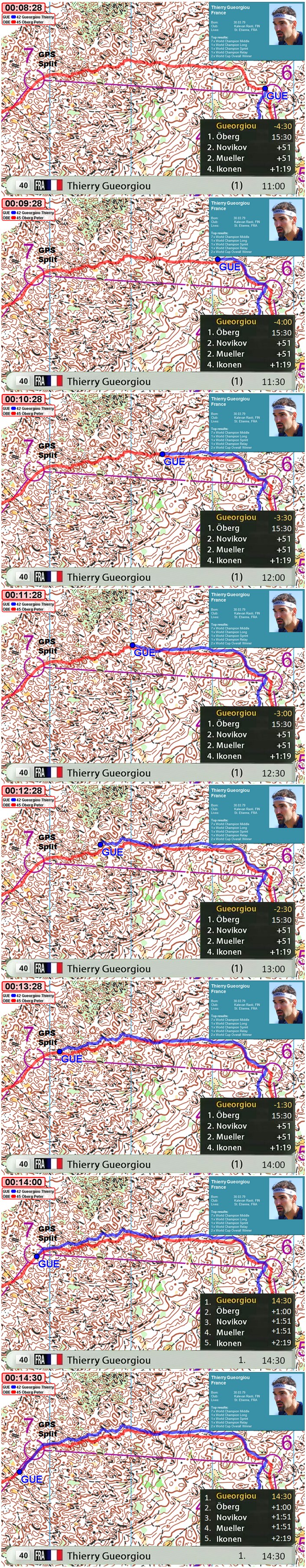
GPS LIVE SYNC
Show one runner live and the remaining runners in a simulated mass start (the symbols LIVE and SYNC are used in GPSSeuranta). The counterpart of REAL TIME LIVE scene for interval start races. One of the most often used scenes in interval start races as it updates the current standing continously between selected runners. Not relevant for first-to-finish races.
Aim:
- Show the current standing / who is in the lead at a position in the course for an interval start race
Advantages:
- The best way to show the current standing at a point in the course live in an interval start race
- Good for bringing out the drama / story telling in an interval start race
Disadvantages:
- Live means that runners move very slowly on the map - not much happening
- Requires some explanations for the viewer to understand. Could consider some improved graphics to make it more clear who is shown as replay and who is live (e.g. route already drawn with thinner linewidth for runners who are shown in replay?)
Productions:
- Most newer WOC productions, typically last part of the race in deciding moments. e.g. WOC 2010 middle distance Carl Waaler Kaas versus Peter Öberg in the short last loop ; Waaler Kaas in replay and Öberg live.
GPS REPLAY SYNC TO LIVE SYNC transition
Counterpart of GPS REAL TIME REPLAY TO LIVE transition for interval start races. The scene starts with a replay, and then goes into live. Not relevant for first-to-finish races.
Aim:
- Just as GPS REPLAY SYNC, but due to the combination of (higher speed) replay and live you can (1) show more of the course in shorter time and (2) get the advantage of live for the story/drama
Advantages:
- Combination of showing more of the course and live for the drama
Disadvantages:
- Difficult to explain to the viewer
Productions:
- Used in several of the latest WOC productions.
GPS TIME TO BEAT
The GPS Time to beat scene is a special version of GPS LIVE SYNC or GPS REPLAY SYNC TO LIVE transition where focus is on the standing at a given control (a GPS split) where the time difference to leader is shown. The GPS tracks stop when they reach the GPS split, and a counter shows the number of seconds behind (and if possible also position of the runner at this point in the course). The same GPS split should typically be used for many runners for the viewer to get to know the split. The chosen leg/area should be either technically difficult or with route choice options.
This has not been used yet, thus there is no video. A graphic has been prepared to illustrate the principle:
Aim:
- Use GPS tracking data in a way which (1) lets the viewer really get to know part of the course, (2) aids in the story-telling in a good way and (3)
Advantages:
- Can be used as part of the story telling as an "extra camera position", giving added value at a low price
- When the same leg is shown several times, the viewer gets to know the leg, and understands more of the challenges. "Knows more than the runner"
Disadvantages:
- If not coupled to the timing system (official splits), the splits will be inaccurate with +/- 5-10 seconds. However, nobody will know until after the race, and thus the problem is not that big(?)
- "Live" is actually 30 seconds late
- If GPS data is missing for a central runner who is around the lead, it is difficult to hide the problems.
Productions:
- Used to some extent in the Norwegian big screen project, but not all the way
Notes:
- Can be integrated with the same type of graphics as the rest of the TV productions - showing runner names, time behind, position etc.
- A GPS split could typically be a leg far from TV controls, to help build the story in this part of the race.
- Can be coupled to split time from timing system at a control to give a real split time (due to 30 second offset of GPS this can work flawlessly)
- Can also be shown as a GPS Replay from start scene if there is no time slot to show live due to other occurences at the time).
GPS COURSE REPLAY
Replay the complete course. Typically shown after the event while waiting for the medal ceremony. Shows the development in the race. Can be done either real time (for first-to-finish races) or from start (interval start races). Special case of GPS Replay real time scene or GPS Replay from start scene.
Aim:
- Show how the race developed, how the lead changed, the decisive places, etc.
Advantages:
- Best way to replay the action and give the viewer an overview over what happened in the race
Disadvantages:
- A lot of information in short time - need a good commentator to relay the important information to the viewer
Productions:
- Used in several of the WOC productions
GPS REAL TIME modes
Runners are shown real time without offset relative to each other.
GPS REAL TIME LIVE
Show a selection of runners at their current position. The most used scene type for first-to-finish races (mass start / chasing start / relay), but not as useful for interval start races (for interval start, use live from start). For interval start it was used extensively in the early days of GPS tracking (as this is the easiest scene type to get out of GPS tracking software), and also used to some extent in big screen productions. The symbol "LIVE" is used in GPSSeuranta.
Aim:
- Show the current standing in a first-to-finish race
- Show how the runners are positioned relatively to each other in the course "just now".
- Show how the runners influence each other (e.g. groups, tactics).
Advantages:
- The best way to show the current standing in a first-to-finish race
- The easiest GPS scene type to explain to the viewer ("where are the runners just now")
Disadvantages:
- Does not aid the story telling a significantly in interval start races
- Live means that runners move very slowly on the map - not much happening
Productions:
- All first-to-finish TV productions (WOC 2011, WOC 2010 etc.)
- Several other TV productions
GPS REAL TIME REPLAY
As REAL TIME LIVE, but replay. Shows a replay of the position of runners as a function of time. This scene type is used a lot for first-to-finish races (mass start / chasing start / relay) to replay the action. Not as useful for interval start races where you will see how the runners are running according to each other in the forest, but not the current standing (for interval start races, use REPLAY SYNC).
The symbol "REPLAY" is used in GPSSeuranta.
Note:
- Too high replay speed may make it difficult for the viewer to understand what is happening (often the case?)
Aim:
- Show how the runners were positioned relatively to each other during the course, and how they influenced each other.
Advantages:
- As for LIVE. In addition faster replay means that it is often more interesting for the viewer (suits the TV format better)
Disadvantages:
- Not live, and thus less dramatic than live scenes. Note: Use replay-to-live to get "the best of both worlds"
- Not good for interval start races - use replay from start instead
Productions:
- Used in most TV-productions from orienteering to some degree
GPS REAL TIME REPLAY TO LIVE transition
Combination of REPLAY and LIVE scenes. The scene starts with a replay, and then goes into live. For first-to-finish races.
Aim:
- Just as REAL TIME, but due to the combination of (higher speed) replay and live you can (1) show more of the course in shorter time and (2) get the advantage of live for the story/drama
Advantages:
- Combination of showing more of the course and live for the drama
Disadvantages:
- Difficult to explain to the viewer
- Not to be used in interval start races - use from start counterpart instead
Productions:
- Used in several of the latest WOC productions.
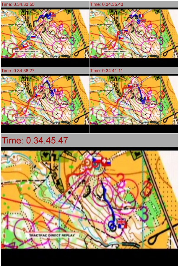
GPS LEG REPLAY modes
Runners shown synchronized to same start time from a given control, i.e. with simulated mass start for a certain leg.
Replay a single leg with simulated mass start at the control which defines the start of the leg. As GPS Course replay scene, but for a single leg and with the simulated mass start from a control and not from the start. To be used both for first-to-finish races and interval start races.
There is no special symbol in GPSSeuranta for leg replay - uses the same as replay from start (REPLAY + SYNC). This makes it difficult to understand for the viewer - a symbol should be introduced. This video from the World Cup Middle distance in Liberec 2011 shows an example:
Aim:
- Show how a single leg influenced the overall result by comparing top runner (primary aim - important part of the "storytelling")
- Show which choice is the fastest/best on a single leg (secondary aim)
Advantages:
- The best way to show how a section of the course influenced the overall result
Disadvantages:
- Need special explanation to the viewers
- Comment from Pekka Varis (GPSSeuranta): They used this a lot in WCup Liberec but clearly it was problem for viewers to understand (especially in chase start) that runners weren’t actually together in starting control but they were synchronized to that, because software hadn’t any “leg replay” –indication. I’ve later added it to LIVE/REPLAY/SYNC –info boxes.
Productions:
- Used in some WOC productions, e.g. World Cup 2011 Liberec
Notes:
- Today's single leg replay does not show "result board" with leg times / time lost. This would increase the usefulness of single leg replay's.
- It is possible to show "ideal route"/"route planners choice" along with the choices
- A GPS Leg replay scene is similar to a single-leg preview of route choice options in some respects. See Map-based course preview.
- Note also the special case where only part of a leg is considered (not used in practice yet).
- The state-of-the-art replay software GPSSeuranta Pro does not (today) give the possibility to fast replay "leg N for runners who either are Top X overall or Top Y on this leg". A single-click option for this would make it easier for an GPS-operator to make good and fast single-leg replays.
- Could show split screen with complete leg + actual position. Better visualize that this is "leg replay"
GPS Show mistake/time loss scene
Show a mistake or a time loss for a runner. This is an important part of telling the drama in a race. Four ways to do this:
- GPS Replay single runner showing mistake (or Replay to Live)
- GPS Replay single runner + leader (or leader group) showing mistake
- GPS Live with long tail showing complete mistake
- GPS Live along with a static ideal route
Aim:
- Show how a runner (typically a favourite) lost time at a special section/point in the race. Important part of the story-telling.
Advantages:
- The best way to show the viewer why a certain runner has lost time
Disadvantages:
- No special disadvantages
Productions:
- Used in all productions, e.g. in WOC 2011 showing how some of the runners did big mistakes on the relay
Notes:
- Possible to make a tool which automatically identified mistakes/time losses for selected runners. Easier for GPS operator(s). Master Thesis underway on this topic at NLH, Norway.
GPS tracking providers
TBD: Some more information about the providers, link to webpages, screenshots
- GPSSeuranta. WOC 2011, WOC 2010, NORT
- TracTrac. WOC 2008 - sample:
- Hungarian provider. WOC 2009
- 3DRerun*. Not actually a GPS tracking provider, but rather a GPS tracking visualization solution. Partly used in WOC 2010, Norwegian big screen project